

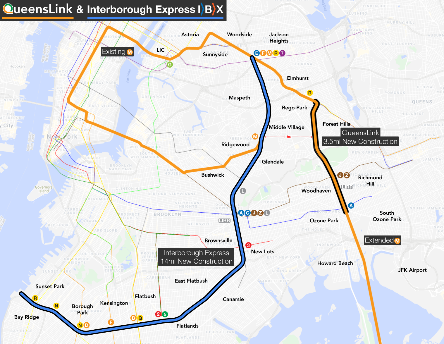
What’s the difference between the IBX and QueensLink?
What is the timeline for QueensLink?
Why does QueensLink propose a subway, not light rail or bus rapid transit?
How will QueensLink address bike infrastructure?
“Why was the M train chosen? Why not another line or a new line?
Which end of the Rockaways will QueensLink serve?
How will QueensLink allow for the G train to be extended to Forest Hills?
Will transfers to other lines be provided?
Will the proposed tunnel impact my building?
What will be done about the noise of the trains?
I don’t live in Queens. How will this help me?
What is the current status of the project?
If the subway takes far longer to build, why can’t we build the park first?
What’s the difference between the IBX and QueensLink?
The IBX and QueensLink serve fundamentally different places.
- The Interborough Express (IBX) is an MTA proposal designed for traveling between Brooklyn and Queens. This stand-alone, light rail line is about 1.5 miles to the west of the QueensLink, connecting Bay Ridge, Brooklyn and Jackson Heights, Queens. These tracks run along an active freight line, and the proposal does NOT contain any park component.
- QueensLink is a vision to reactivate the abandoned LIRR Rockaway Beach Branch between Rego Park and Ozone Park, creating the FIRST North-South subway connection in Queens. It would extend the existing Queens Blvd Line, linking up with the A train, and continuing to the Rockaways. Along with transit, QueensLink would include 33 acres of park space for local communities.
Is QueensLink feasible?
Yes. A 2018 MTA study declared that it is feasible to restore rail service on the Rockaway Beach Branch as an integrated part of the subway system, serving approximately 47,000 daily riders. It also mentioned the possibility of including park space along the right-of-way.
What about the Queensway?
The Queensway is an opposing scheme to build a “High Line-style” linear park along the entire right-of-way, founded on the idea that rail reactivation was not feasible and would never happen. With grant funding from former Governor Andrew Cuomo and corporate backing, Queensway developed a plan that, if built, would block transit use.
In September 2022, Mayor Eric Adams announced his support for constructing the first section of this linear park, called the Metropolitan Hub. The New York City Parks Department and Economic Development Corporation are currently developing this narrow, half mile stretch.
Instead, QueensLink was born with the idea that Queens needs BOTH rails and trails. By combining subways and park space, we can have a more effective and positive impact on local communities.
Who will fund this project?
Projects like QueensLink are typically funded by a combination of local, state, and federal funding through the MTA’s capital budget.
What is the timeline for QueensLink?
Over the past few years, the QueensLink team has conducted extensive community and political outreach. Our next step is to perform a Draft Environmental Impact Statement, which is a legally-mandated analysis to fully understand the costs and benefits of the project. This study will take about two years. Construction will likely take between 6-8 years.
If selected for inclusion in the MTA’s next (2030– 2034) capital plan, QueensLink could be built by the end of 2030s.
Why does QueensLink propose a subway, not light rail or bus rapid transit?
QueensLink is particularly effective because it connects two parts of the existing subway system. In doing so, it provides more frequent service on existing lines, more in-system transfers across the network, lower overhead costs, and better direct service between Queens and Midtown Manhattan.
In its 2018 sketch assessment, the MTA concluded that LIRR service would be limited to only a few trains per hour, attracting only 11,000 daily riders. However, subway service would be much more frequent, serving about 47,000 daily riders.
BRT would require riders to make multiple transfers, eliminating any potential time savings. Additionally, this transit option would take up more space, eliminating all park components from the plan.
Light rail would require riders to make multiple transfers, eliminating any potential time savings. This option would also necessitate a new storage and maintenance facility, increasing overall costs.
How will QueensLink address bike infrastructure?
Bike infrastructure is a key component of QueensLink, as Central and Southern Queens are almost entirely devoid of safe bike lanes. Similar to this project’s North-South subway connection, QueensLink will also include a North-South bike network along the right-of-way.
Beginning at the Queens Blvd bike lane, new protected bike lanes will pass through the new park space along the existing embankment. South of Metropolitan Ave, the bike lanes will cross over the LIRR Lower Montauk Line on a new rail bridge. From there the lanes will enter Forest Park, connecting with the existing network from there.
South of Forest Park, the right-of-way narrows, and cannot support dual use. The NYC DOT has proposed on street bike lanes in Woodhaven and Richmond Hill, which should be installed to connect with Forest Park. New protected bike lanes will be included between Atlantic Ave and Liberty Ave.
Additionally, bike racks can be installed at all new QueensLink stations.
“Why was the M train chosen? Why not another line or a new line?
In their 2018 report, the MTA proposed rerouting some M and R trains along the Rockaway Beach Branch. This would reduce overall service to 67th Ave and 71st Ave-Forest Hills stations. Splitting service like this will also cause an imbalance in headways, reducing service reliability in Queens, Manhattan, and Brooklyn. It would also cause rider confusion about which trains are going where, a problem currently faced by A train riders in southern Queens.
It is better to extend one whole line rather than split two so that service levels and reliability are kept stable. If the R were extended, it would become so long that it would cause staffing issues, requiring train operators to have uncommonly long shifts. The M, on the other hand, is shorter, and so any extension will not overwhelm operators. While the M currently does not serve Queens Blvd late nights, there are many options for creating late night service. This will be evaluated based on potential ridership during the Environmental Impact Statement.”
Which end of the Rockaways will QueensLink serve?
QueensLink’s M train extension could terminate in either Far Rockaway or Rockaway Park, eliminating the Rockaway Park Shuttle. Our Initial Business Case report only looked at replacing the shuttle to Rockaway Park with the M train, but this was done for simplicity. The routing will ultimately be determined by travel patterns and potential ridership. This will be studied as part of the Draft Environmental Impact Statement.
How will QueensLink allow for the G train to be extended to Forest Hills?
Right now, the Forest Hills-71st Ave Station limits local capacity because trains can only terminate on one track, whereas the standard terminal layout uses two tracks This limits current M and R service to about 20 trains per hour (TPH), even though signals on the line can handle 30TPH.
QueensLink would divert the M train (which currently runs at 9TPH) to the Rockaways instead of terminating at Forest Hills-71st Ave. This opens up 10TPH capacity on the local tracks, which the G train could fill.
Will transfers to other lines be provided?
QueensLink will have in-system transfers at Jamaica Ave (J, Z) and Liberty Ave (A). Riders will also have access to E, G, F, R, and 7 trains via existing connections.
The new Atlantic Av-Woodhaven station could include a connection to the LIRR Atlantic Branch via a reopened Woodhaven LIRR station.
Will the proposed tunnel impact my building?
In order to connect with the Queens Blvd Subway Line in the North, the QueensLink plan includes a new tunnel North of Metropolitan Ave. This means that Rego Park and Forest Hills will NOT see a new above-ground train.
After working with the community, the QueensLink team identified an alignment along 67th Ave that would allow the tunnel to pass far below existing buildings in order to minimize negative impacts. Combining this approach with modern tunneling technologies means that QueensLink will have NO IMPACT on nearby buildings and their foundations.
What will be done about the noise of the trains?
In QueensLink’s above-ground sections, design approaches will take extra care to eliminate noise and vibration impacts. Our team is considering modern solutions such as continuously welded rail, sound-absorbing ties, sound barrier walls, and existing vegetation as natural barriers.
I don’t live in Queens. How will this help me?
Even if you don’t live in Queens, this could help you get to your Queens destinations faster AND provide better service on existing lines. Queens Blvd Line (E, F, M, R) riders would have an extended G train for better inter-borough connections. Better service to southern Queens will reduce crowding on both the A train AND nearby roads. Most of all, everyone will benefit from a cleaner environment with less pollution.
What is the current status of the project?
The QueensLink team has spent the last few years engaged in extensive community and political outreach across the borough. Together, we have built a strong coalition of neighborhood groups, community members, and local leaders who want to see action on this project.
In 2025, we were able to secure a $500,000 planning grant as part of the US DOT Reconnecting Communities Initiative. We will be using this money to lay the groundwork in advance of a Draft Environmental Impact Statement.
If the subway takes far longer to build, why can’t we build the park first?
We can absolutely build the park first! However, any combination of rails and trails on the right-of-way requires careful consideration of how these elements work together. After all, you shouldn’t start planting your landscaping before you build your house. That’s why we’re conducting extensive studies and community consultation to determine the best design approach for everyone.
