Forest Park, Woodhaven & Richmond Hill
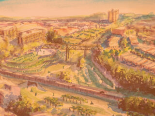
Between Union Turnpike and Atlantic Avenue, features of the old Rockaway Beach Branch right-of-way pose challenges to park and transit usage and create exciting opportunities to innovate. The tracks in this section ran through a natural ravine in Forest Park and then on a narrow earth embankment south of the park.
In the QueensLink plan, pedestrian and bicycle paths would continue alongside the rails from Forest Hills over a new bridge crossing the LIRR Lower Montauk Branch and Union Turnpike into Forest Park, where they would connect to the existing trails and paths. South of the park, however, the embankment is too narrow for both rails and trails. Our plan calls for running new tracks on the embankment and diverting bicycles to a new bike lane on 102nd Street that would give cyclists safe passage down to Atlantic Avenue, while protecting the privacy of homeowners with backyards along the right-of-way.
Sound walls, natural forest and vegetation barriers, sound-deadening rail beds, and at one point, an above-ground tunnel, would minimize train noise and protect the privacy of people living along the right-of-way. This portion of the QueensLink has four sections: Union Crossing, Forest Park Greenway, Camouflaged Tracks, and Jamaica Station.
The Forest Park, Woodhaven & Richmond Hill section contains 4 parts:
- Union Crossing, including:
- A new bridge to be built spanning the LIRR Lower Montauk rail line, which will feature walking and bike paths on either side of the tracks
- A new bridge over Union Turnpike
- A covered rail section from Union Turnpike to Forest Park to reduce noise next to the Forest View Crescent building
- Forest Park Greenway
- Camouflaged tracks, including:
- Sound walls covered in vegetation
- continuously-welded tracks for noise reduction
- a tree and vegetation buffer along the sides of the embankment
- Jamaica Ave station:
- a free transfer to the 104 St station on the J/Z line will need to be studied

Union Crossing
The old Rockaway Beach Branch line crossed over the LIRR Lower Montauk Branch line and Union Turnpike on a wooden bridge that burned down long ago. The QueensLink plan includes a new bridge that would carry two subway tracks, along with dual-use pedestrian and bike paths.
The path would provide access to the Ridgewood, Glendale, Middle Village, and Maspeth (RGMVM) Little League ball fields and to the Union Turnpike service road entrance on the south side of the Turnpike. The path would also provide access to the Forest Crescent apartment building and the mall north of it.
Between Union Turnpike and the entrance to Forest Park, the tracks would run through a small residential neighborhood, with single-family homes to the west and the large Forest View Crescent apartment building to the east. To protect residents of this area from the sight and noise of trains, we propose building an above-ground tunnel, with pedestrian and bicycle paths along the eastern side.
To mitigate sound pollution, an innovative solution has been devised: an above ground tunnel. This tunnel would block both the sound and visual impact on the nearby homes, and prevent the sound from being channeled upwards, into the apartments in the tower. On the east side of this tunnel would run pedestrian and bike paths that would connect the Forest Hills Greenway to Forest Park.


Forest Park Greenway

- NYCT right-of-way and maintenance walkway
- Forest-lines pedestrian pathway
- Bidirectional bike lanes
- Forest Park Drive overpass
- Overpass access stairs (dual mode ramp on opposite side of overpass)
- Rebuilt retaining wall
The right-of-way through Forest Park is wide enough for two active rail tracks, with pedestrian and bike paths alongside them. However, the embankment’s western side has deteriorated for decades; a new retaining wall would have to be built between the embankment and adjacent homes. This retaining wall would also provide a sound barrier, shielding the homes from train noise, while chain link fencing would keep people off the tracks.
Within Forest Park, access to the Greenway paths from the roads crossing over them would be built at Myrtle Avenue and at Forest Park Drive. Myrtle Avenue runs lower than Forest Park Drive, so a simple ramp between the road and Greenway using the natural slope of the site would suffice.
Forest Park Drive sits much higher, however, so a much larger ramp would be needed. On the north side of the Drive, the ramp would zig-zag, descending the slope; the paths would not be not too steep for bicyclists and pedestrians. Stairs built into the south side of the Forest Park Drive overpass would provide a second way to enter and exit the Greenway. Brighter lights and security cameras would be added for increased visibility and safety.
South of Forest Park Drive, a second pedestrian path would be built west of the tracks. This path is now an unofficial path within Forest Park, connecting Forest Park Drive and Park Lane South, it would be upgraded and outfitted with lighting, and the retaining wall next to the Forest Park Co-op apartment building would be rebuilt and provide a sound barrier.
 The Forest Park Greenway would end at Park Lane South, but the paths would continue on the rail bridge crossing Park Lane South, with entrances for bicyclists and pedestrians on each end of the bridge. On the east side, the bike lanes would turn and extend to 102nd Street, connecting to a north-south bike route proposed by NYC Department of Transportation (DOT).
The Forest Park Greenway bike path would create a bike path axis, so that bikers from the east and west can travel north and south, and vice versa, safely.


Camouflaged Tracks

Local community groups and individuals near the right-of-way frequently voice concerns about safety and noise. Hundreds of homes abut the abandoned tracks; some of them are fairly close to the tracks; others are set back. The only things separating these homes from the tracks are old chain link fences. We propose installing several sound and sight-reducing technologies used successfully in similar projects around the world that would, in effect, camouflage the trains passing nearby homes.
Many trees now grow between the old tracks; these would be cleared, so trains could run on new tracks, but trees growing on the embankment’s sides would be left in place, so they could continue to serve as a forested buffer. A sound wall, similar to those along highways, would be built between the trees and the tracks to deflect sound upward and away from nearby homes, and block views of trains from nearby homes–and views from the trains into homes. The sound wall would also prevent trespassers on the tracks from breaking into homes. Encouraging natural growth, such as ivy, on the sound walls would further reduce noise and visually camouflage the walls.
Lastly, trains running on earthen embankments are much quieter than elevated trains New Yorkers are familiar with. Earthen embankments deaden sounds, while the steel latticework of the elevated 7 and J trains amplifies sounds. Also, the QueensLink route here would be relatively straight, unlike the sharply curving J train tracks; as a result, the trains’ metal wheels wouldn’t squeal nearly as much. Continuously welded tracks, damping pads, and a concrete track base would further reduce train noise.


- Existing earth embankment and bridge over 91st Ave
- NYCT right-of-way and maintenance walkway
- Forested and natural vegetation buffer
- “Living” sound wall with natural vegetation
- Perimeter fencing along neighboring backyards, preventing trespassing
- Neighboring buildings
Sixty years of natural growth has turned the Rockaway Beach Branch right-of-way into a forested buffer that adds to the serenity of backyards along the route. Its abandoned state, however, has led to camping and partying on the line, and illegal dumping of old tires, beer bottles and other debris. Upgraded fences along the lot lines back would protect residents’ privacy by ending use of their backyards as passageways to the tracks

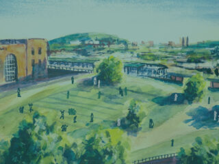
Jamaica Ave Station
A new, ADA-accessible Jamaica Ave station would be built at the site of the former LIRR Brooklyn Manor station, at 100th Street, with a connection to the 104 Street station of the Jamaica Line. Creating a free transfer would maximize use of both lines and network effects that benefit the whole system. The best option would be to build a physical passage, elevated above the street, providing a free transfer between the two stations, like the elevated passage at the Broadway-Junction station in Brooklyn. This option requires further study.

Another option is to replace the 104th Street station’s entrance at 102nd Street, which was removed many years ago. This would provide ADA-compliant access to the 104 Street station closer to Jamaica Avenue station, but an out-of-system transfer would need to be provided.
Between Jamaica Ave station and Atlantic Ave station further south, the right-of-way would feature the same camouflage techniques as are proposed for the tracks south of Forest Park. Bike lanes would be located on 102nd and 103rd streets, as proposed by the NYC DOT.
Before-and-after view down the platform of the Jamaica Ave station.